
Snap it, upload it, find out what it isIdentify a Photo

Photo

Fill the frame with the thing you want identified, in good light.

Where Is This

Where is this? Upload a photo to see the place, the clues that point to it and how sure the AI is.

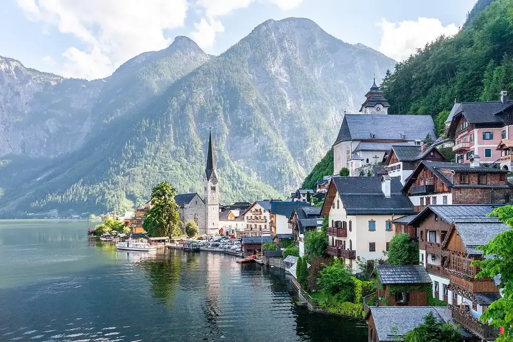
A lakeside village with a church spire under mountains, an example photo for where is this
Example

Hallstatt, Upper Austria, Austria

Historic lakeside village · UNESCO World Heritage Site

Confidence: 99%

Use this for travel photos and landmarks, not to find where someone lives. A location guess from a photo can be wrong.

This is the world-famous alpine village of Hallstatt, situated along the southwestern shore of Lake Hallstatt (Hallstätter See). It is unmistakably recognized by the slender spire of the 19th-century Evangelical Church on the water's edge, traditional 16th-century Alpine wooden houses, and dramatic backdrop of the Dachstein Alps.

Location

Settlement
Hallstatt
Water body
Hallstätter See
State / Region
Upper Austria (Salzkammergut)
Country
Austria

Clues in the photo

Prominent church
Evangelical Parish Church (Christuskirche)
Hillside church
Catholic Parish Church of the Assumption
Architecture
Multi-tiered timber-and-plaster Salzkammergut style
Mountains
Sheer limestone peaks of the Salzkammergut Alps

About the place

Heritage status
UNESCO World Heritage (1997)
Historical claim
Home to the world's oldest salt mine
Archaeology
Namesake of the Iron Age Hallstatt culture

Quick Facts

  • Salt mining in Hallstatt dates back over 7,000 years, making it home to the oldest documented salt mine in the world.
  • Because the village had very limited space for a cemetery, graves were traditionally exhumed after 10 to 15 years to store bleached and artistically painted skulls in the local charnel house (Beinhaus).
  • A full-scale replica of Hallstatt was built in Huizhou, Guangdong province, China, in 2012.

Did you know?

Until the late 19th century, Hallstatt could only be reached by boat across the lake or via narrow, treacherous mountain trails; the first road carved into the rock face was only completed in 1890.

It could also be

  • Obertraun, Upper Austria, Austria15%
  • St. Wolfgang im Salzkammergut, Upper Austria, Austria10%
  • Brienz, Bernese Oberland, Switzerland5%

An example answer. Upload your own photo to identify it.

How to find where a picture was taken

One photo in, one answer card out, usually in 10 to 20 seconds.

  1. 1

    Upload the photo you're asking about

    Drag in or pick one JPG, PNG, WebP or HEIC photo. Use the original file from the camera or phone when you have it, not a screenshot or a forwarded copy.

  2. 2

    GPS is read first, if the file has it

    Before anything is sent, your browser checks the original file for saved GPS coordinates. If it finds them, the where is this card shows them on their own line with an Open in map link, and the AI gets them as evidence.

  3. 3

    The AI reads the clues and answers where is this

    Without GPS, the AI works from what the photo shows: landmarks, buildings, signs and their language, road markings, plants, mountains or coastline. It names the place, says how sure it is and lists look-alike places.

How to read a where is this answer

The card opens with the place, written as place, town or city, country, then a line on what kind of place it is and the AI's own confidence. On our sample lakeside photo, which had no GPS, the where is this answer was Hallstatt, Upper Austria, Austria at 99%.

Three groups follow. Location breaks the answer down by settlement, water body, region and country. Clues in the photo lists what the guess rests on: in our example the church spire on the shore, the timber-and-plaster houses and the limestone peaks behind them. About the place adds background, then come quick facts and the places it could also be. Ours were Obertraun at 15%, St. Wolfgang at 10% and Brienz in Switzerland at 5%.

Why some photos get a landmark and others a country

A where is this answer only goes as far as the evidence in the frame. A famous building or a readable sign can point to one spot. A street of ordinary houses may only show the country from its architecture and road markings, and a plain beach or forest may show very little.

The AI is told to name a landmark or street only when it can tell, to give just the region or country when that is all the photo shows, and to keep its confidence moderate then. Saved GPS is different: it is a reading from the camera, not a guess, which is why the card shows it on a separate line. Photos shared through social apps and chat apps have usually lost it.

Tips for a better where was this picture taken guess

A where is this guess depends far more on what the photo shows than on anything else, so pick the shot with the most clues.

  • Use the original file from your camera roll, since it is the copy most likely to still carry GPS.
  • Keep the whole scene: a crop that removes the skyline, the street or the hills removes clues too.
  • Pick a shot where signs, shop names or station names are sharp enough to read.
  • Prefer an outdoor view with a building, bridge, tower or coastline in it over a close-up or an indoor room.
  • Choose a daylight photo over a night shot, where buildings and terrain blur into the dark.
  • If the confidence is low or the alternatives are close, try another photo of the same spot with a wider view.
  • Only upload travel photos and public places, never a photo meant to find where someone lives.

Photo location privacy and limits

What happens to your photo, and how far to trust a where is this answer.

  • Made for places, not people

    Every where is this answer carries the same note: use this for travel photos and landmarks, not to find where someone lives. If a photo shows a private home or a person, the AI is told to name the town or region at most.

  • Confidence is the AI's own estimate

    The percentage is how sure the AI says it is of the place it named. It is not a measured accuracy rate, and a location guess from a photo can be wrong.

  • Your photo is not kept

    Your photo is sent to the AI model only to identify it; we do not save it or use it to train AI models. The GPS check runs in your browser, and the answer stays on the page only until you refresh or leave.

  • Free, with no account

    Every visitor gets five free scans a day, shared across all the identifiers on the site and reset at midnight UTC. There is no sign-up and no credit card.

Frequently asked questions

Upload it to the where is this box at the top of this page. If the file still has GPS, you get the coordinates and a map link; if not, the AI names the most likely place from the landmarks, signs, buildings and terrain it can see.

Yes, when the photo has enough clues. For where is this, a well-known landmark or a readable sign gives the best chance; a generic field, beach or room may only get a country or a low-confidence guess.

An exact point only comes from GPS saved in the file, which the tool shows as coordinates you can open in a map. Without it, the answer is the place the AI thinks the photo shows, as specific as the evidence allows, not a street address.

The AI works from the picture alone. Screenshots and photos saved from social or chat apps usually have no GPS, so for those the card relies on the clues listed under Clues in the photo.

This page can only speak for itself. Here, one where is this upload returns a place name, the clues behind it, a confidence figure and look-alike places, without an app or an account.

This tool can't tell you that: it doesn't look for the same picture online or for who posted it first. It reads what the photo shows and names the place; to find where an image appears on the web, use a reverse image search engine.

This page doesn't read your device's position. It works out where a photo was taken, from the GPS saved in the file or from what the picture shows.

There is no tested accuracy figure, so we don't quote one. Check the confidence, the listed clues and the alternatives; close runners-up or a low score mean the photo didn't carry enough evidence.

No. Where is this is for travel photos and landmarks. When a photo shows a private home or a person, the AI is told to give the town or region at most.

One JPG, PNG, WebP or HEIC photo at a time. It is resized in your browser before it is sent, after the GPS check has read the original file.